Blog
Joining village maps, explained
Guides for anyone who downloads a village survey map from the Commissionerate of Survey and Settlement and needs to put the sheets back together.
What is the F-line in a survey? Meaning, sketch & F-line application
'F-line' means two different things. On an FMB sketch it is the field boundary of a survey number. In Andhra Pradesh and Telangana an 'F-line application' is a petition to re-fix that boundary on the ground. Here's both, explained.
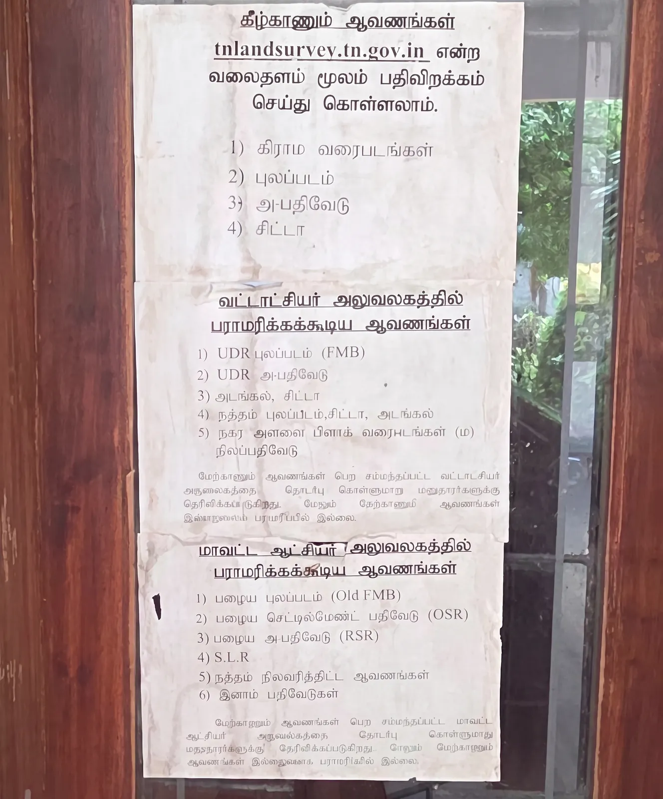
Tamil Nadu Land Records Online: What You Can Download and What Still Needs an Office Visit
A clear breakdown of which Tamil Nadu land documents you can download from tnlandsurvey.tn.gov.in — village maps, FMB, chitta, A-Register — and which ones (UDR FMB, Old FMB, OSR, RSR, inam registers) you can only get from the Taluk or District Collector office.
Get your FMB sketch the easy way: order online, we download it for you (₹99)
Don't want to wrestle with OTPs, dropdowns and a portal that keeps timing out? Tell us your district, taluk, village and survey number, pay just ₹99, and we download your FMB sketch from the official Tamil Nadu e-Services portal and send it to your WhatsApp shortly after payment.
Get your whole village map joined into one — done for you (₹1699, print-ready PDF)
Your village map comes as separate sheets (S1, S2, S3, S4) and joining them correctly is tricky. Let us do it: we source the sheets from the Survey & Settlement portal, stitch the adjacent sheets into one continuous map, and deliver a print-ready PDF in 1–4 hours for a flat ₹1699.
What is the G-line in a survey map, and how do you read it?
Spotted a thick outer line on your FMB sketch or village map marked 'G'? That's the G-line — the village boundary. Here's what the G-line means, how it differs from the F-line, and how to read it on your survey sheet.
Tamil Nadu Village Map Joiner: combine your village map sheets into one
Bought or downloaded a village map in Tamil Nadu and got several separate sheets? Tamil Nadu Village Map Joiner stitches the adjacent survey sheets into one continuous, high-resolution map — free to assemble and preview, right in your browser.
How to get your FMB sketch and village map in Tamil Nadu (2026 guide)
Where and how to download your FMB sketch, Patta, A-Register and full village survey map online in Tamil Nadu — from the official Survey and Settlement and e-Services portals — and how to join the sheets into one map.
Downloaded a village map from the Survey and Settlement website? Here's how to join the sheets
If you downloaded a village survey map from the Commissionerate of Survey and Settlement, Tamil Nadu and it came as several separate sheets, Village Map Joiner stitches them back into one continuous map — right in your browser.
Tamil Nadu land records glossary: Patta, Chitta, FMB, A-Register & more
A plain-English (and Tamil) glossary of the land-record terms you'll meet on the official portals — Patta, Chitta, A-Register, Adangal, FMB, Nanjai, Punjai, Natham, Poramboke, TSLR and the officials behind them.
Step by step: from downloaded survey sheets to one joined village map
A simple walkthrough — collect your sheets from the Survey and Settlement portal, upload, auto-arrange, fine-tune the seams, and export one clean map.
What are S1, S2, S3, S4? Understanding adjacent village survey sheets
A quick explainer on why village survey maps are split into numbered sheets, how they fit together, and how to join them without losing detail.
How to download a digital village map in Tamil Nadu
Stop queuing at the Taluk office — download your village map online from tnlandsurvey.tn.gov.in. Here's the step-by-step, the small fee, and what to do if it says 'Not Available'.
Patta, Chitta, Adangal & A-Register: what's the difference?
Patta shows who owns the land, Chitta its classification, Adangal what's growing on it — and the A-Register is the 'mother record' behind them all. What each Tamil Nadu land record means, how they differ, and where to get each one online.
How to apply for a Patta name transfer online (without a middleman)
Save money by doing your own Patta name transfer. Here's the portal to use, the documents you need, and how to track your application with the reference number.
FMB Full Form & How to Read an FMB Sketch
FMB = Field Measurement Book — the official sketch of one survey number. Learn to read the F-line, G-line, measurement ladder and its units (metres, chains, links), step by step.
What is 'Natham' land? (And why it's sometimes missing online)
Living in the old village centre? Your land record may be different. A quick explainer on Natham settlements, the Natham survey, and Thoraya vs clean patta.
The history of land survey in Tamil Nadu: from chains to drones
Your land was likely first measured by a British colonel in the 1800s. A short history of surveying in Tamil Nadu — from the Great Trigonometrical Survey to modern DGPS resurvey.
Old survey number vs new: how to use the Correlation Statement
Got an old deed with an old survey number that doesn't match your current patta? The Correlation Statement tool links old survey numbers (OS) to new resurvey numbers (RS).
Licensed surveyors in Tamil Nadu: the list, fees & who to call
Need your land measured in Tamil Nadu? Here's who to call: government (Firka) surveyors vs private licensed surveyors, how to find the official district-wise list, what they charge, and when you don't need a surveyor at all.